Posts

Navigation Courses

Image
Each year, autumn sees an increase in people booking onto our navigation and map reading courses . We like to think that this is in preparation for winter where shorter days and the chance of poor weather can be more of a challenge if someone were to get misplaced in the mountains or on the moors. However the reality is that a significant number of people go out walking over the summer, enjoy it but get a bit lost. It’s this group that provide the majority of our autumn bookings. Introduction to Moorland Navigation Course Peak Navigation Courses provide a range of map reading courses and navigation courses from complete beginner to expert standard where people attend to refine or revise their skills.  Our Introduction courses both start with around 1.5 hours spent in the classroom (Foolow Village Hall) which is then followed by a walk taking in a range of landscapes that includes both open moorland and fields.  Both Introductory courses teach the basics of navi...

A Summer of testing navigation!

Image
The only good point about the British “Summer” that we have been experiencing is that it’s been testing the navigation skills of those visiting the moors and mountains.   With all the low cloud, rain, drizzle and wind, visibility has been poor on more days than not. This is why it’s essential to know how to map read and navigate. Peak Navigation Courses provide a range of navigation training from the complete novice up to the expert wanting practice for undertaking Mountain Leader assessments. Peak Navigation Courses Autumn Programme is now available.

Peak Navigation Courses

Image
Well our Spring season ofMap Reading and Navigation Courses is drawing to a close.   This year we have put on additional courses due to demand and the positive feedback we have received has been great.   It’s been wonderful for us too, as ever making new friends and even learning a thing or two from our students. One of the highlights was discovering the compass that pointed south! Peak Navigation Courses are now running Hill Skills Courses based in the Peak District looking at a complete range of skills: Mountain Safety, Weather, Equipment, Navigation, GPS Navigation, Scrambling and Ropework. Photo’s of this years courses are also on the website.   Check them out to see if you are there.   If you have any pictures from your course that we could use, please send them in. With our other company, Sierra Nevada Guides we are also running Mountain Skills Courses based in Spains Sierra Nevada .   This course builds on the navigation you’ve lear...

Choosing Trekking / Walking Poles

Image
Choosing Trekking / Walking Poles As an advocate of poles and professional walking guide I get the chance to lead many people in the hills and mountains of Britain and Europe.  The vast majority of serious walkers are these days already using poles, there is a reason for this: “A 2010 study by UK-based Northumbria University shows that using trekking poles reduce muscle damage and soreness in the days following a hike. The combined benefits of using trekking poles in reducing load to the lower limbs, increasing stability and reducing muscle damage also helps avoid injury on subsequent days of trekking, according to Dr Glyn Howatson. Trekking poles can also reduce the compressive force on the knees by up to 25%, according to The Journal of Sports Medicine in a 1999 study.” The advantages of using trekking poles are: 1.            Extra stability  on difficult or loose terrain If you walk off path or in the mou...

Scrambling in The Peak District

Image
Scrambling in The Peak District Yes it's official!  With the Publication by Cicerone of a new guide to scrambles in the Peak there is sure to be a surge of interest in scrambling.  We at Peak Navigation Courses and Mountain House have been leading people up various scrambles over the years as part of our navigation courses and guided walks . Scrambling? Scrambling is great fun and occupies that area between hill walking and rock climbing. At its easiest (grade 1 scrambles) it requires the occasional use of hands to move between boulders or up rock slabs, whilst at its hardest (grade 3 scrambles) are easy rock climbs. The scrambles that we are offering to lead and supervise are all either grade 1 or grade 2 scrambles that do not routinely require the use of a safety rope. That said, our qualified leaders will carry safety equipment in case anyone has trouble or finds themselves lacking in confidence. These are all day itineraries starting at 10am and aimin...

Hill and Mountain Skills Courses

Image
Hill and Mountain Skills Courses Peak Navigation are keen to promote hill and mountain safety and enable people to enjoy getting out into the hills safely. Our hill and mountain skills training courses are available both for those new to hill walking and as a "refresher" for the more experienced. The courses includes: Mountain Safety, Weather and Equipment; Navigation, using a map and compass, route choice and using a GPS.  This 4 day course is based in The Peak District.  Details can be found on the Peak Navigation Courses website. The 7 day Mountain Skills course is  based in Spain's Sierra Nevada Mountains and additionally includes scrambling and some rope work. This is both valley based and hut based (1 or 2 nights) including ascents of Mulhacen and Alcazaba. Cost from £550 depending on your choice of accommodation and includes your pick up from malaga Airport and final drop off.  Further details can be found on our  website Sierra Nevad...

Which GPS for Hill Walking?

Image
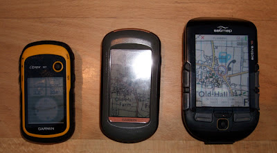
Choosing a GPS (for Hill Walking) A friend recently asked me this question as someone involved in organising GPS training courses that can be trusted to give an unbiased view. However, even being objective and unbiased I could only provide an answer within my experience (being confined to Garmin, SatMap and ViewRanger). The Smart Phone / View Ranger. I’ve had View Ranger on my Phone and smart phone for 5 years and though I find its functions as good or better than any proper GPS device (easier to use and better functions) I’d never rely on it for when the chips are down. Phones have poor battery life and don’t run View Ranger for more than 8 hours. Phone’s are not usually shock proof, dust proof or water resistant. Great in good conditions.  Keep your phone in tact with the batteries fully charged in case you need to summon help! GPS Devices. You need to make a choice: firstly do you want one that has OS mapping installed or one with out? Secondly if you have chosen ...