Posts

Showing posts from 2013

Learn Map Reading and Navigation with Peak Navigation Courses

Image
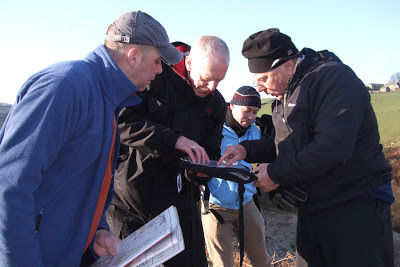
Learn Map Reading and Navigation with Peak Navigation Courses Silva Type 4 Compass Being able to map read and navigate well is not only a means to keeping safe on your walks but is fun too!   It’s great being set free from guide books and have the ability to plan your own walks. Peak Navigation Courses run a range of courses from those suitable for absolute beginners through to “ Navigation Master Classes” aimed at providing a testing day with useful revision for those already expert. There is something for everyone! Most courses are 1 day courses, usually on a Saturday or Sunday and there is scope for progression through the courses. 1st Steps to Map Reading and Navigation Course The 1 st Steps to Map Reading and Navigation Courses is a good foundation level course that goes through the basics of map reading and how to use a compass. The day starts with a classroom session then progresses to a short walk through fields before lunch.   During lu

New Season of Map Reading and Navigation Courses

Image
Our first Map Reading and Navigation course of the Autumn 2013 season got off to a successful start, with 9 participants, one of whom continued to our Intermediate Course the following day, and as a result achieved his Silver National Navigation Award . Despite an uncertain weather forecast, it stayed dry and mostly sunny offering great views from Longstone Moor during the afternoon, when we were able to put those new found skills of reading the map and using the compass to the test. There are plenty of places left on Peak Navigation courses during November, so if you know anyone who may be interested, do pass on the details.

Map and Compass Course

Image
New to walking and just starting out? Map and Compass Peak Navigation Courses run a course just for you!   “1 st Steps to Map Reading and Navigation” is a  course designed for the beginner or the person who has always left the navigation to others.   It takes you from the absolute basics and leaves you equipped to plan routes and navigate both through fields on paths and off path on easy moorland. This course can be combined with a 2 nd day to achieve the Bronze (NNAS) National Navigation Award. Map Reading Course Map and Compass Course Having the skills required to navigate using a map and compass gives you the freedom to move away from books of walks and to plan your own routes. An example of this is of Bamford Moor in the Peak District where I live. Here there are two stone circles and according to the map there are no paths leading to either of them. Peak Navigation Courses’ “Introduction to Moorland Navigation Course” will leave you equipped

Foreign Maps

Image
BL***Y Foreign Maps Mike and Jane from Peak Navigation Courses spend the summer months guiding people in the mountains. This summer will see us in Spain’s Sierra Nevada, Swaziland, Mozambique, Scotland and Slovenia. As International Mountain Leaders we are trained and assessed at using all sorts of foreign maps.   We have a lot to be thankful for in the U.K. as our Ordnance Survey maps are perhaps the best in the world. It also makes navigation easier with good maps and makes for safer enjoyment in the mountains. Map extract - Spain's Sierra Nevada In the UK our maps show crags and rock features. This is especially useful as you wouldn’t want to take a line over a cliff.   The map above is from Spain’s Sierra Nevada.   From the contour lines it appears that these are nice rounded hills with no crags at all.    The cliffs at point A on the map The next pictures below show Jane climbing / scrambling at points A and B on the map! Not a hint of a crag on

Silver National Navigation Award in a Weekend

Image
Silver National Navigation Award in a Weekend Learning to navigate in the snow Peak Navigation Courses ran a Silver NNAS course over the Easter weekend for Natural Born Hikers, a “Meet Up” group from London. Ten students in total attended the weekend which was staffed by Jane, Mike and Steve from Peak Navigation Courses.   Normally the Silver NNAS is just a two day course but being Easter the course was extended so that after the Silver NNAS, we included a night / poor visibility navigation session on Big Moor and looked at some more advanced navigation techniques on Kinder Scout. All ten students achieved the standard and had a great time. Night Navigation on Big Moor   Peak Navigation Courses have a programme of Navigation Courses, either 1 day or 2 day (NNAS) based in The Peak District throughout the year. Day courses are priced from £40 per person whilst the 2 day NNAS courses are £85 per person. The courses run by Peak Navigation Courses are

More Navigation in the Snow!

Image
More Navigation in the Snow! Peak Navigation Courses run a series of “Quality Days“ or Navigation Master classes aimed at allowing people who can already navigate the chance of some more testing navigation in remote locations. Last Sunday’s course certainly proved that in snowy conditions on Bleaklow with high winds and wind chill temperatures estimated to be -8 degrees (though I thought colder). Setting off from Birchin Clough car park we ascended Lady Clough before crossing the Snake Road onto Bleaklow via Upper North Grain. Difficult navigation on featureless terrain - Navigation Masterclass Quality Day on Kinder Scout Specifically we practised pacing and pacing in snowy conditions where there is a significant loss of traction requiring more paces to 100m. After joining the Pennine way which we followed for 300m, we continued off path navigating to obscure pools and spot heights; via Over Wood Moss before reaching the shelter and welcome respite of Oyster

NNAS Course Dates and Prices 2013, by Peak Navigation Courses

Image
Peak Navigation Courses Dates for our NNAS training and Assessment Courses 2013. Peak Navigation Courses have now finalised the dates for their NNAS courses in 2013. Our cost for these 2 day NNAS Courses is £85 (non residential). Learning to use a compass Bronze NNAS:              25 th and 26 th May 12 th and 13 th October 9 th and 10 th November both days based from Foolow  in the Peak District Silver NNAS:                          1 st and 2 nd June 19 th and 20 th October 16 th and 17 th November day 1, based from Foolow;   day 2, near Edale For the Bronze and Silver courses, you don’t have to commit to a whole weekend, you can mix and match the dates to suit you,     i.e. for bronze you could have day 1 on 25 th May and day 2 on 13 th October. Gold NNAS Training:              Based on Keswick in the Lake District 26 th and 27 th October Navigating to the stone circle on Eyam Moor Our cost for all of the

NNAS Courses being run by Peak Navigation Courses

Image
NNAS Courses being run by Peak Navigation Courses Peak Navigation Courses are pleased to now be delivering NNAS (National Navigation Awards) in The Peak District.   We have recently been accredited as NNAS trainers and will be adding a full list of courses into our autumn programme.   It will however be possible to gain the silver award by arrangement (completing both our Introduction to Moorland Navigation Course and our Intermediate Navigation Course with some assessment built in). Locating our position on the map The Bronze training and assessment will be a two day course based from the village of Foolow.   The two days can be consecutive or spaced out over different weekends.   Day one being our normal 1 st Steps to map reading and navigation course but day two being a newly devised day specific to the bronze syllabus and allowing time for assessment. Learning to use a compass The silver training and assessment will follow the present courses that w

Winter Navigation in the Snow

Image
Navigation in the Snow Peak Navigation Courses run navigation training throughout the year in The Peak district National Park.   For the past two weeks we have been enjoying (?) some snowy conditions which give a different slant to walking and navigating in the hills. Yesterdays “Intermediate” Navigation Course went ahead albeit with an altered itinerary. Just walking in deep snow takes substantially more effort which is compounded when walking off path and through steep terrain.   There was further heavy snowfall through the night before the course and only four of the eight booked made it through (though this did include students attending from Cambridge and Luton). Some "re-location" near the bottom of Jacob's Ladder Then it was off path taking various zig zags from one attack point to another through “The Cloughs” to locate the wreckage of two old aircraft wrecks. A further steep ascent to The Wool Packs led us to the Edge Path which we f