AZ Adventures 1:25000 scale maps for walkers

Thanks to the wonders of social media, I had been offered these to review. During this particular course, I talk about the various mapping options available to walkers, and had often mentioned the AZ maps, but never actually bought one. I included them in the list that morning, and the group of relatively experienced walkers were quite impressed, and I have to say so were we.
 So what makes AZ Adventures different? The most obvious is that in keeping with AZ a pedigree, these are uniquely in a book or atlas format, which means no wrangling with large cumbersome maps, a wonderful bonus when it is blowing a gale out in the hill. This does mean you have to flick over the pages occasionally, but there is a reasonable overlap and the pages to look for are well marked. There is also a detailed key, again much easier to use than on a big map, which I have to confess I have not looked at in detail for quite a while. The area covered by each of the booklets is similar to the Ordnance Survey Explorer White and Dark Peak maps, but with a generous 5km overlap, which means that although our village is still only on the White Peak map, Eyam moor, where we visit regularly is on both.
The second unique feature for me is the presence of an index - if you know where you want to go this is a really useful feature - so the somewhat obscure hamlet of Bretton, with just 4 houses, a pub is included, as is the youth hostel and Abney Low, a small hill nearby. The index includes not only page details, but also a grid reference, just to confirm you have it right; all really useful and easy to use. Also at the back of the atlas are a couple of pages of safety advice for walkers and off road cyclists.
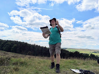
 The paper and print quality in our copies was really good, making the mapping easier to read than our standard OS Explorer maps. The booklet fitted really well into the purpose designed map case (perhaps just a little too well, as we struggled to get it out!). The case would I am sure keep the map dry in most conditions, our only quibble really being that when using it with a compass, it wasn't quite 'sticky' enough for the compass not to slide around.
This leads to our only real criticism of the AZ product; the print didn't quite line up between pages, so if you are using a compass to get a bearing or measuring distance on the map, you would find using the the atlas format more difficult and certainly less precise. This is particularly the case if the two points are on different pages, when in certain cases taking a bearing would be impossible.
So in conclusion; we really like the AZ Adventure atlases, and would definitely use them out on the hill, but not in situations where we planned to do some complicated navigation - for that sadly the big cumbersome map sheets, folded precisely to where we want to go, will have to prevail.
Thanks again to AZ for sending us the maps. We were given copies of the Peak District White and Dark Peak atlas, but the comprehensive series covers most of the popular walking areas of the UK and some long distance trails. They can be bought at most outdoor retailers or from AZ themselves price £7.95