Foreign Maps
BL***Y Foreign Maps
Mike and Jane from
Peak Navigation Courses spend the summer months guiding people in the
mountains. This summer will see us in Spain’s Sierra Nevada, Swaziland,
Mozambique, Scotland and Slovenia.
As International
Mountain Leaders we are trained and assessed at using all sorts of foreign
maps. We have a lot to be thankful
for in the U.K. as our Ordnance Survey maps are perhaps the best in the world.
It also makes navigation easier with good maps and makes for safer enjoyment in
the mountains.
 |
| Map extract - Spain's Sierra Nevada |
In the UK our maps
show crags and rock features. This is especially useful as you wouldn’t want to
take a line over a cliff. The map
above is from Spain’s Sierra Nevada.
From the contour lines it appears that these are nice rounded hills with
no crags at all.
 |
| The cliffs at point A on the map |
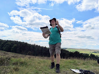
The next pictures
below show Jane climbing / scrambling at points A and B on the
map! Not a hint of a crag on the map, and Spain is supposedly a developed modern country.
 |
| The cliffs at point B on the map |
Peak Navigation Courses will be running again from mid October and it would be good to see you
on one of our courses or “Navigation Masterclasses.” The autumn programme is on
the website and the winter / spring programme will follow shortly.
We have some places
left on some of our holidays and courses: