Choosing a Navigation Course
Peak
Navigation Courses, Which is the
Right Course For Me?

Prior Experience. None
required.
Classroom based with 2
short walks of 1.5 hours and 2 hours.
Terrain
encountered.
Paths, fields and some rough pasture on easy moorland.
 |
| Fun Learning new skills on the 1st Steps Course |
Maps, suitable maps
for walkers, different scales of maps, what the maps tell us about the ground,
how to use a map for navigation.
How to make a route
plan, how long is the route, how long it will take to walk the route. Including
understanding six figure grid references
What to do if things
go wrong whilst out walking.
How a compass can be
used in a range of situations and how to follow a compass bearing.
Pacing and timing as
navigation techniques.
Clothing, equipment
and staying safe.
Follow up:
After attending the
course we will send you some “practice” routes for you to have a go at using
your new skills without us.
Additionally we will
invite you to join any of our (free) guided walks to come and get some more
practice with us. These are held 8 times a year in the Peak District.
 |
| Learning to use a compass for the first time. |
Prior Experience.
The ability to use a
compass to take a bearing from a map, preferably be familiar with the navigation techniques of
following a bearing, pacing and timing.
A short indoor session
but mainly based outdoors with a walk of around 5 hours.
Terrain encountered.
Paths through fields
though mainly on “access land” involving some steep ground and rough pasture.
 |
| Moving onto Moorland |
A short revision about
map scales and the factors that are essential for a good compass.
Revision of Pacing and
timing.
Using different scale
maps for navigating through complex terrain.
Navigation using
contour features and understanding contour features.
Revision of using a
compass.
Some advanced compass
techniques, reversed bearings and back bearings.
Problem solving and
re-location (where are we).
Micronavigation (techniques
for finding things accurately) on moorland and in poor visibility.
Follow up:
After attending the
course we will send you some “practice” routes for you to have a go at using
your new skills without us.
Additionally we will
invite you to join any of our (free) guide walks to come and get some more
practice with us. These are held 8 times a year in the Peak District.
 |
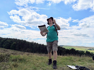
| Learning some precise "micr-navigation" techniques on the Moving onto Moorland Course. |
 Prior Experience.
You will already be
confident with basic compass use and experienced on rough terrain off path.
This is a day long
outdoor course normally lasting 6 to 7 hours though may be shortened due to
poor weather.
Terrain
encountered.
Some paths though
mainly rough challenging moorland. Some steep ascents and stream crossings.
On this course you will learn about:
Precise
micro-navigation techniques across challenging featureless terrain.
Re-location techniques
including back bearings and aspect of slope.
Navigation across
steep ground and contouring.
During the day there will be a chance for “revision” of the range of techniques covered in our other courses.
 |
| Advanced Moorland Navigation. Operating at this level you have "The Keys to the Kingdom" |
An
Intermediate level Course
 Prior Experience.
The ability to use a
compass to take a bearing from a map,
preferably be familiar with the navigation techniques of following a
bearing, pacing and timing.
A walk of around 3
hours usually from around 6.30pm until 9.30pm in the winter months.
Terrain encountered.
Some paths though
mainly crossing open moorland involving rough boggy ground.
On this course you will learn about:
Strategies for
navigation in poor visibility.
Learn to use pacing
and timing as navigation techniques.
Develop further
compass skills.
Gain confidence
navigating and moving in poor visibility.
About Peak Navigation Courses:
 Peak Navigation Courses has been established since 2004 and currently teaches around 300 people a year the basics of Map Reading and Navigation.
Mike & Jane who run Peak Navigation Courses are both qualified as International Mountain Leaders having been trained and assessed in navigation to the highest standards both in the U.K. and overseas.
As IML's Mike & Jane have to keep their skills up to date and have to demonstrate that they have undertaken additional (cpd) training each year.
Mike and Jane are members of The Mountain Training Association and the British Association of International Mountain Leaders.
Peak Navigation Courses are accredited to run the National Navigation Awards and hold the NNAS Tutors Award.
About Peak Navigation Courses:
 Peak Navigation Courses has been established since 2004 and currently teaches around 300 people a year the basics of Map Reading and Navigation.
 Mike & Jane who run Peak Navigation Courses are both qualified as International Mountain Leaders having been trained and assessed in navigation to the highest standards both in the U.K. and overseas.
As IML's Mike & Jane have to keep their skills up to date and have to demonstrate that they have undertaken additional (cpd) training each year.
Mike and Jane are members of The Mountain Training Association and the British Association of International Mountain Leaders.
Peak Navigation Courses are accredited to run the National Navigation Awards and hold the NNAS Tutors Award.