Kinder Scout claims more scalps!
Autumn has arrived
early this year as we didn’t seem to have much of a summer. Looking at the
mountain rescue call out reports, the Peak District moors have certainly been
proving too much for many ill prepared walkers who have ended up having to be
rescued. It’s not just about poor map reading and navigation
skills and the over reliance on GPS navigation technology, but also about
having the skills, clothing and equipment to deal with the difficult terrain,
which has become extremely boggy after the summer rains.
The Following is an extract from Buxton Mountain Rescue Team call out log:
 “Buxton
Mountain Rescue Team called out as night fell to search Kinder moor for two
walkers who were trapped by deep bog without lights or whistle. Although
the casualties, a married couple from Doncaster, had no apparent injuries, they
were very cold and disorientated. The night was damp and misty at high
level, with some wind. They had set off for a days walk from Edale, up
Grindsbrook to Kinder Downfall. Returning on a GPS bearing, the female
became trapped in deep wet bog at 16.30 hrs. After freeing themselves from
this, the couple were keen to find a way out off the boggy area – but could
not, and became trapped as darkness fell. They had no torch, but did have some
food and spare clothing. They were able to give a grid reference of their
location to the police when they dialed 999. This proved accurate, and it was
straightforward for rescue team members to locate them. Following a warming up in
a box tent, the couple were led via Grindslow Knoll back to Edale, arriving at
23.30. As they were not injured, they were able to drive back home.”
“Buxton
Mountain Rescue Team called out as night fell to search Kinder moor for two
walkers who were trapped by deep bog without lights or whistle. Although
the casualties, a married couple from Doncaster, had no apparent injuries, they
were very cold and disorientated. The night was damp and misty at high
level, with some wind. They had set off for a days walk from Edale, up
Grindsbrook to Kinder Downfall. Returning on a GPS bearing, the female
became trapped in deep wet bog at 16.30 hrs. After freeing themselves from
this, the couple were keen to find a way out off the boggy area – but could
not, and became trapped as darkness fell. They had no torch, but did have some
food and spare clothing. They were able to give a grid reference of their
location to the police when they dialed 999. This proved accurate, and it was
straightforward for rescue team members to locate them. Following a warming up in
a box tent, the couple were led via Grindslow Knoll back to Edale, arriving at
23.30. As they were not injured, they were able to drive back home.”
As part of the “Moors for the Future” project, many of the Groughs (drainage
channels) that cross the centre of Kinder Scout have been dammed up to prevent
soil erosion. The effect of this has been to make an already boggy area into a
seriously boggy and even dangerous area, where those with little experience or
facing darkness can find themselves in frightening conditions. The situation
has been made more serious by the very wet summer that we’ve had this year.
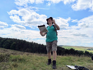
When you join us for a course run by Peak Navigation Courses, we look at the range of skills
necessary for safe moorland walking. There are specifically three courses
available aimed at enhancing navigation and hill walking skills in moorland and
mountain situations.
 |
| Introduction to Moorland Navigation Course |
A 1 day course, designed for people
who have done some walking, which will enable you to use a map and compass to
navigate over open moorland.
The 1 day “improvers” navigation
course for people who already know the basics of using a map and compass. The
course involves a walk of approx. 10.5 miles crossing the centre of Kinder
Scout.
3. Night Navigation
(for poor visibility conditions).
 |
| Night Navigation Course |
Trying to find your way when the mist
comes down, or it is getting dark can be frightening. Planning to walk in
the dark is great fun if you have the skills to navigate safely. This 3
hour evening course is designed for people who have basic map and compass
navigation skills, and want to learn more advanced techniques.
For those who have become proficient
in their navigation, we offer a series of “Navigation Master-classes”
throughout the year where we spend the day revising and practicing skills
during some exacting navigation challenges.
Peak Navigation Courses are run by qualified International
Mountain Leaders who are keen to ensure that people enjoy the hills safely and
not become another mountain rescue statistic!
 |
| Introduction to Moorland Navigation Course |